ERMES (an Earth obseRvation Model based ricE information Service) is a FP7 Project funded by the European Commission with the objective of developing a prototype of downstream service dedicated to the rice sector to support authorities and farmers.
The agricultural sector is facing important global challenges due to the pressure of food demand, increased price-competition produced by market globalization and food price volatility (G20 Agriculture Action Plan). In particular, farming activity in Europe has to maintain and improve its competitiveness by reducing production costs and minimizing environmental impact of agricultural practices through a sustainable use of natural resources.
In this framework, ERMES aims to create added-value information for the rice sector by integrating in crop models operational Copernicus core products, maps derived from SAR (Synthetic Aperture Radar) and optical Earth Observation data processing and in situ observations.
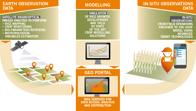
Two ERMES services will be created for Regional authorities and Local agro-business. Advanced smart technologies will be used to collect in-situ observations and return customised information to end-users and spatialised maps will be provided to end users through the use of advanced web-services including the ERMES Geoportal.
ERMES services aim to
- Provide information to regional authorities for the implementation of agro-environmental policies;
- Support farming activities, with particular focus on the development of sustainable management practices;
- Provide independent reliable information to the agri-business sector.