(English)
In 2016 ERMES team added to the portfolio of products available to support farmers in their agropractices during the season a new service based on regular monitoring of crop condition at the beginning of the season just after sowing exploit all weather condition VHR SAR data.
The product is aimed at detecting the rice field homogeneity conditions in the first part of the rice season (April to July) in Greece, Spain and Italy. The activity was carried out by analyzing 3 m resolution SAR data acquired alternatively by COSMO-SkyMed 1 and 2 in HH polarization with 8 days repetition frequency.
The products consisted of geocoded binary files showing two types of classified homogeneity maps:
- Single date homogeneity : it represents the spatial variability within each field, as detected in a single CSK acquisition;
- Multi-temporal variability : it represents the temporal variability within each field, as detected by comparing the field conditions in subsequent CSK acquisitions.
The maps contain 5 classes; on the basis of the average SAR backscatter of the field, each pixel is classified as: “low” or “very low” (i.e. backscatter value lower or much lower than the average); “about mean” (i.e. backscatter close to the average value). “high” or “very high” (i.e. backscatter value higher or much higher than the average);
The 5-classes discrimination allows characterizing the field as follows:
-
during the sowing/flooding stage: “low” or “very low” classes represent areas where the water better covers the ground (e.g. soil composition differences, proximity to the irrigation source, drainage pattern variability, etc.) or the terrain is better levelled than the average in the field. The opposite behavior must be attributed to the “high” or “very high” classes.
-
during the first part of the rice growing period (till about panicle initiation): “high” or “very high” classes represent areas where the rice is growing better than the average in the field.
-
After panicle initiation: in this period the rice canopy starts closing and the SAR signal decreases progressively, therefore in this phase “low” or “very low” classes represent areas where the rice is growing better than the average in the field.
The homogeneity maps have been validated and practically exploited on the field to assess, at the season begin, the variable germination time within a field. This year in particular the information was essential due to a dry spell in the first part of spring when the early seeding happens. Indeed the areas of the fields affected by delayed growth – due to the lack of standing water in the more permeable sandy soils – were clearly detectable as “low” or “very low” classes.
Moreover, about one month after seeding, the homogeneity maps showed how the plants were recovering well in the clay soils (where moisture remains higher and persistent), while in the sandy terrain the situation was critical due to a crust, which impeded a smooth plant emergence.
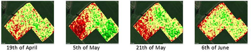
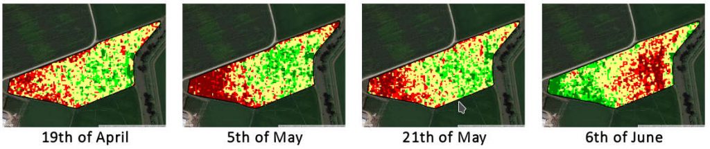
The figures show some examples for two fields belonging to ERMES users’ farms.
In the first Carnaroli variety was planted the 7th of April. It is a field characterized in the bottom-left part by sandy/lime soil that progressively becomes more clay in the right part. The first SAR homogeneity maps clearly shows problem in emergence in this area. The problem is more clearly visible in the 5th of May map when rice is emerged in the whole field and the red area shows the part where plants are suffering for low germination and/or delay of growth. The farmer action of a variable fertilization at the tillering stage, exploiting the ERMES information provided, allowed to partially recover this issue as can be appreciated in the 6th of June map.
A similar situation can be found in the second case representing a field sown, the 7th of April, with the variety Mare. Also in this case the different soil texture impacted on the germination showing a clear scalarity from the bottom left corner of the field (19th of April).
In conclusion the timely provision of homogeneity maps from VHR SAR data proved to be an helpful support to manage crop variability recovering critical situation at the beginning of the season. More info can be found in the online publication on the rice farmer journal “Il risicoltore”
http://www.enterisi.it/upload/enterisi/gestionedocumentale/IlRisicoltore07-2016_784_40060.PDF